Monday, 5 August 2013
Hiking the Grand Canyon
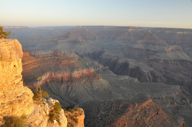
The one thing I remembered from our last hike into the Canyon more than 30 years ago was the bolded caution from the rangers to allow double the time for the hike up - if you hiked for an hour into the canyon, it would take you two hours to come back up the same distance. With that firmly entrenched in our minds and the understanding that we are now older and that it could possibly take us longer than double the time, we hiked into the canyon on the Kaibab Trail, starting off from Yaki Point. We found that going down was not as easy as it looked - it was quite steep, there were many switchbacks. We felt it mostly in our knees. Meeting breathless older people coming up the trail was enough of a reminder to not overdo it. We took our time as there were lots of photo ops - it was a scenic trail.

We found out from one of the riders what was in the cargo - garbage hikers left behind in the canyon!


 |
| Note the switchbacks downs the side of the canyon |
 |
A mule train coming up the canyon |

We found out from one of the riders what was in the cargo - garbage hikers left behind in the canyon!

 |
| This was where we stopped for lunch - the point was aptly named because there were indeed a lot of oohing and aahing at the view |

 |
And more than one species admiring the view... |

 |
Looking back at the trail going up, we decided it was time to go back. We were only 780 ft. down but it felt like a long descent because of the switchbacks. We expected the ascent to take twice as long but it turned out to be not too bad - we were pleasantly surprised - apart from our knees, our lungs were in better shape than we thought. |
 |
| An artist at the top - I too wish I could paint this... |
Sunday, 28 July 2013
Catching the sunrise at the Grand Canyon
Catching the sunrise was quite different from catching the sunset. With the sunset, it was just a matter of checking your watch and making sure you get to the right spot on time. The sunrise was a whole different battle - setting the alarm, even going to bed earlier the night before, packing your gear ahead of time, the struggle to get up when the alarm rang, stumbling out of bed, putting on warm clothing, then driving through the darkness when you're still half awake. The mild surprise when you saw a crowd already assembled at your chosen location, then angling for the perfect spot, settling for second best if you're not early enough... there seemed to be a whole set of unspoken rules and protocol around this, not blocking someone else's view but asserting yourself if necessary. It all made for a very complicated exercise in striking the right balance when your mental faculties are still groggy with sleep.
But the cold dawn would soon take care of that. As you stood waiting in the cold, hands frozen, but still snapping away because there was nothing else to do while you wait, you caught every shade of rock as the sun inched upwards. So what if you're wasting disc space - there's plenty. When the sun peeked through, there was a sudden sense of everyone for himself, because there were only precious seconds before the whole blinding star came up and you couldn't point your camera at it any longer. And almost with a collective sigh of relief, everyone went off for breakfast.


But the cold dawn would soon take care of that. As you stood waiting in the cold, hands frozen, but still snapping away because there was nothing else to do while you wait, you caught every shade of rock as the sun inched upwards. So what if you're wasting disc space - there's plenty. When the sun peeked through, there was a sudden sense of everyone for himself, because there were only precious seconds before the whole blinding star came up and you couldn't point your camera at it any longer. And almost with a collective sigh of relief, everyone went off for breakfast.
 |
The light and the view is very similar to sunset - only in reverse (from Yavapai Point) |


 |
| The sun was seconds away from popping up |
 |
| and finally it's up - just swing the camera to the other side to watch the lengthening light |

Spots lit up as the sun crept higher

And slowly the magic wand lit up the canyon - see how each lighted patch lengthens with every passing minute  |
TIme for breakfast... |
Wednesday, 24 July 2013
Sunset at Yavapai Point, Grand Canyon
I remember my first view of the Grand Canyon in 1979 - the lump in my throat and tears in my eyes. The magnificence and enormity of that landscape touched me deep where words failed. That must have been what conversion felt like. But I was a believer then so it was more an affirmation of the presence of God. I remember going to the village book store and looking for a book of poetry that might adequately express what I couldn't. I didn't think I found anything I wanted to buy. But that experience remained through the decades, back and forth between conversions and faith-busting "de-conversions" - it was like a candle that someone had kept burning for me all these years in some dark chapel. Something to be cherished because that first impression was difficult to recapture...
I brought with me on this third visit, a better camera and a better lens and I like to think I took better pictures although the former two things may have no bearing whatsoever on the latter. But I was unable to recapture that first impression. On reflection, I think what I needed was more time for contemplation. It requires a state of mind quite different from what I brought with me this time - the search for the perfect photo spot, the search for the right aperture, the search for the perfect light. It clearly calls for a fourth visit, one where I just sit there and watch the sunset instead of trying to figure out which f stop to use.
I brought with me on this third visit, a better camera and a better lens and I like to think I took better pictures although the former two things may have no bearing whatsoever on the latter. But I was unable to recapture that first impression. On reflection, I think what I needed was more time for contemplation. It requires a state of mind quite different from what I brought with me this time - the search for the perfect photo spot, the search for the right aperture, the search for the perfect light. It clearly calls for a fourth visit, one where I just sit there and watch the sunset instead of trying to figure out which f stop to use.
 |
Sunset at Yavapai Point |
 |
The light changed very quickly. Sunset took less than a half hour. |
 |
 |
Amen! |
Saturday, 25 May 2013
Off Road Adventure
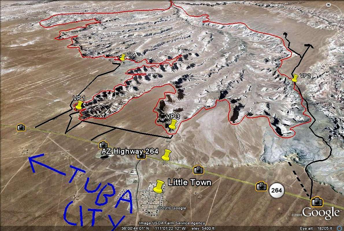
When I read about Coal Mine Canyon on Tripadvisor, I knew I would like to see it and that it might not be easy to find but I didn't bank on a real off road adventure. A blog site I came across gave us the GPS coordinates for the canyon and told us that it was off Hwy 264 approximately 16.4 miles south of Tuba City. Then another post said it was much more than 16 miles. The blog site also had a map of this location. All this information didn't prepare us for the fact that there were absolutely no signs to tell us which dirt road to take off the highway to get to the canyon. That stretch of highway was on Navajo reservation land and there were fences beside the highway. So we looked for a break in the fence quite a bit after the 16 mile point and took our chances. (For those of you who thought you might try this, the coordinates for the entrance to the dirt road are N35.98621 W911.00059)
It was a little adventurous for us, especially when we didn't know whose land we were on, if we were on the right track or headed in the right direction. Several times we thought of turning back but we didn't. The dirt road just went on and on and we came to a point where the track climbed steeply and then dropped - we couldn't really see beyond the top of the hill until we got over it and could very well had dropped down a cliff. But our sense of adventure egged us on. We were also lucky we didn't fall off the edge. We found ourselves at the top of a hill and looking down, canyon land stretched out ahead to the horizon, but no other hint of civilization.

This was an encouraging view and there were other car tracks. So we kept going and figured it would be safe to follow other tracks that went to the edge of the canyon. Even then, we played it safe. We were conscious of the fact that if anything happened to us, we may never be found! We parked our SUV, rented specifically for this purpose, and walked over to the canyon edge. See that speck in the distance at 2 o'clock in the picture below? That's the car.

But what a breathtaking view it was! All the way to the horizon, not a soul in sight! It was all ours to look at. We felt at once the vastness of the land and how small we really were. It was like we were on another planet. According to hikers, you could hike into the canyon but there were no real trails, you just followed whatever looked possible. We were not brave enough for that - imagine falling and breaking a leg or two! There was no cell phone service - how would one even call for help?
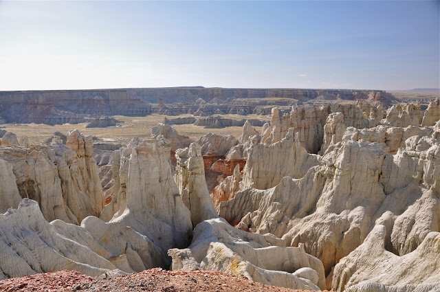
These hoodoos reminded me of Bryce Canyon except these seemed more spread out and had different colours on different layers of rocks.

It was called Coal Mine Canyon for a very good reason - there were large amounts of coal in the canyon, and you could see the coal seams right here (picture below).

Interesting skirt like formations


It was late afternoon when we got there - you could see the different light effect on the canyon walls. When we got into our car and drove to another part of the canyon that caught the low rays of the sun, the walls showed a different colour. Pretty spectacular!

We could see the light fading even as we turned around for more pictures...

So it was time to go back up the hill that we came down -

Probably no big deal for the young, but it was for us an exciting off road adventure - great to do this sort of thing once in a while to keep our nerves in shape...
Wednesday, 15 May 2013
The Famous Horseshoe Bend on the Colorado
After our boat cruise on Lake Powell, we still have an afternoon left to explore the area near Page. The famous Horseshoe Bend, a meander of the Colorado River,is just a short drive south of Page and a short hike from the parking lot. It is quite spectacular and I can imagine it will look different at various times of the day - particularly stunning at sunset. But it is a 1000 ft drop to the bottom and there are no railings. My heart dropped a few times when we were there watching little kids insist they be let go at the edge of the cliff...

 |
| The hike up to the top - the sandy trail required a lot more energy than usual |
 |
| Once you get to the top you go down again quickly - with the gaping hole at the bottom |
 |
| The reward - a stunning view of the Horseshoe Bend - but not for the acrophobic |
 |
Fearless couples... |

 |
| Quite a climb back up to the top |
Thursday, 9 May 2013
Rainbow Bridge - world's largest known natural bridge
After the full day canyon tour, we had a leisurely day doing a boat tour on Lake Powell which included a short hike to Rainbow Bridge, world's largest known natural bridge, considered sacred by the local Native American tribes. It was a very enjoyable cruise, with remarkable scenery throughout the two hours. The worst part was getting up in the morning to get to the marina for the 7:30 am cruise. There was no other option if we wanted to do the hike to the bridge.
The only food provided on board the six and a half hour cruise were granola bars and apples, with coffee and lemonade. If you want real food, there was a sunset cruise which included dinner. But then you won't be able to see the Rainbow Bridge. And I would opt for the monument rather than the food in Arizona - any time.


The way back to the Marina was just as spectacular as we were then seeing the landscape in a different light and from a different angle


The only food provided on board the six and a half hour cruise were granola bars and apples, with coffee and lemonade. If you want real food, there was a sunset cruise which included dinner. But then you won't be able to see the Rainbow Bridge. And I would opt for the monument rather than the food in Arizona - any time.
 |
| Early morning at the marina |
 |
| The same landscape from the water |
 |
| Layered bluffs all along Lake Powell |
 |
Lots of mesas and buttes around the lake |

 |
| It seems that everywhere you look you see camel heads |
 |
Entrance into the canyon leading to the Rainbow Bridge - you wouldn't think the boat could get through the many narrow channels - but it did |

You can see in these two pictures (above and below) what a difference the light can make to the same landscape - the top is an approach to the channel (obviously the wrong angle light-wise) while the photo below is looking back from the other side

 |
| The boat let us of on the pier and we hiked along this massive canyon face to get to the Rainbow Bridge Monument |
 |
First glimpse of the monument with Navajo Mountain in the background |

 |
| The perfect arch - Rainbow Bridge, considered sacred by the tribes in the area |
 |
| Not much snow melt this year - river bed is dry |
 |
| One of many houseboats on Lake Powell docked here at the Rainbow Bridge pier |

The way back to the Marina was just as spectacular as we were then seeing the landscape in a different light and from a different angle

 |
| The ever present coal power generating station has become a monument in its own way |
 |
The dam that created Lake Powell and turned it into a beautiful pleasure playground |

Sunday, 5 May 2013
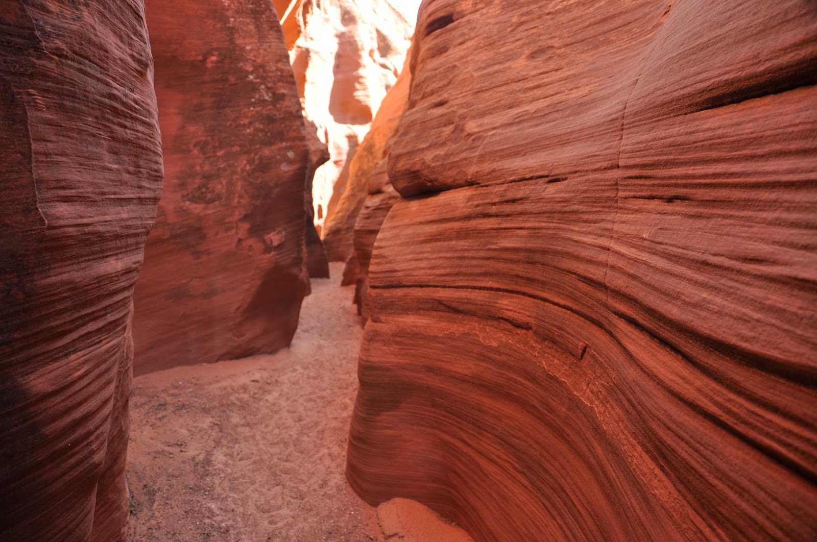
Slot Canyon #5 - Mountain Sheep Canyon
Someone remarked that all the canyons looked very similar. While the pictures of the sandstone do seemed alike, the canyons themselves are actually quite different with their own character. They may all have swirls, but the stone texture seemed different in each of them and they were all different heights and widths, thus creating different feel when you were actually in them. You have to be there.
Mountain Sheep Canyon is the longest canyon of the five (about 1.5 miles) and there is probably a good reason why it's named after the Mountain Sheep - you have to climb up and down quite a few times inside the canyon, like mountain sheep. The step ladders were secured, but one of them was quite long - climbing up seemed easier as long as you don't look down, but climbing down is not for the faint of heart as you do have to look down to make sure you don't miss a step. And you have to go back the same way as there is no other way out. To add to the drama, it was our last canyon of the day, everyone was tired - but we survived.

The entrance to Mountain Sheep Canyon

A well-camouflaged lizard

First time we saw any plant life in the canyons


This canyon is much more rugged than the other four. You can see that in the stone texture and the harsher lines of the swirls.


That was a fairly long climb up to a not very steady platform...

Looking down from the platform

Even the arches you see in this canyon are not as smooth as the ones in the other canyons

Compared to similar shots in the other canyons, you can see the lines here are much more rugged.


And that was the end of our day-long tour of the slot canyons - it was a spectacular adventure!


Slot Canyon #5 - Mountain Sheep Canyon
Someone remarked that all the canyons looked very similar. While the pictures of the sandstone do seemed alike, the canyons themselves are actually quite different with their own character. They may all have swirls, but the stone texture seemed different in each of them and they were all different heights and widths, thus creating different feel when you were actually in them. You have to be there.
 |
| The entrance to Mountain Sheep Canyon |
 |
| A well-camouflaged lizard |
 |
First time we saw any plant life in the canyons |


This canyon is much more rugged than the other four. You can see that in the stone texture and the harsher lines of the swirls.


|
| That was a fairly long climb up to a not very steady platform... |
|
| Looking down from the platform |
|
| Even the arches you see in this canyon are not as smooth as the ones in the other canyons |
 |
| Compared to similar shots in the other canyons, you can see the lines here are much more rugged. |


And that was the end of our day-long tour of the slot canyons - it was a spectacular adventure!
Friday, 3 May 2013
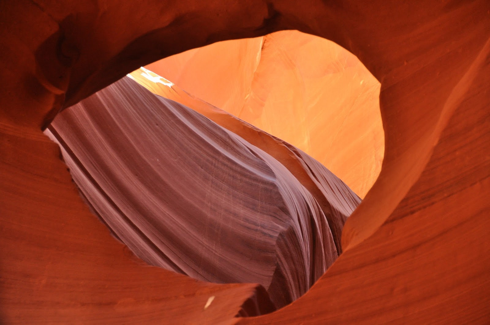
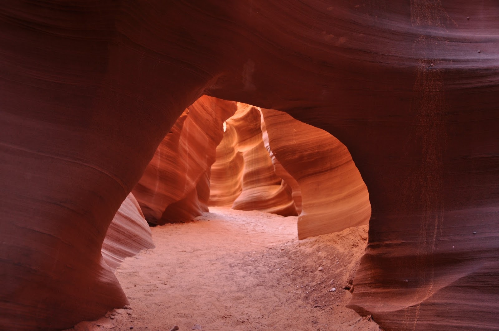
Slot Canyon #4 - Lower Antelope Canyon
I approached this canyon with a sense of adventure and excitement. I was a little anxious about it even when I was looking it up online - this is the canyon where 11 tourists died in 1997 because of a flash flood. There was a memorial plaque near the entrance of the canyon and all who entered were told the scary story of how this happened. Very little rain fell on the canyon that day but a thunderstorm earlier in the day had dumped large amounts of water seven miles upstream. Apparently the group was warned that the flood was coming through but the guide was not a local guide and did not heed the warning as they did not see the water. The homemade wood stairs (since replaced) were washed away with the flash flood and the group had no means of escape. Our guide showed us the now secured ladders in addition to 10 boxes containing rope ladders along the canyon side that could be released if a flash flood occurs.
Lower Antelope Canyon, called Hazdistazi or "sprial rock arches" in Navajo, is the deepest and, in my opinion, the most beautiful canyon in the group with spectacular swirls - you can almost see the water whirling through and carving the spirals in the canyon. The fact that it is all underground made it even more awesome - once you're down there, you're in a different world and you forgot yourself. It was breathtakingly beautiful with a view around every corner. See for yourself...
The entrance is most unusual - guess which is the right hole?


This photo gives you a sense of what it feels like when you're down there surrounded by these swirly rocks

Then it goes on and on and on...


Finally, the way up!


And beyond - the basin where the water would come out...

It is truly amazing!
Lower Antelope Canyon, called Hazdistazi or "sprial rock arches" in Navajo, is the deepest and, in my opinion, the most beautiful canyon in the group with spectacular swirls - you can almost see the water whirling through and carving the spirals in the canyon. The fact that it is all underground made it even more awesome - once you're down there, you're in a different world and you forgot yourself. It was breathtakingly beautiful with a view around every corner. See for yourself...
The entrance is most unusual - guess which is the right hole?

and this is how you get in - how would you know that without a guide?! No need to answer - they won't let you in without one.

Squeeze through then there are steps - much easier than I expected...

This photo gives you a sense of what it feels like when you're down there surrounded by these swirly rocks

Then it goes on and on and on...

You're surrounded...


it's like walking through a dreamscape...


Finally, the way up!

Here's looking back at where we came out -

And beyond - the basin where the water would come out...

It is truly amazing!
Wednesday, 1 May 2013
Slot Canyon #3 Upper Antelope Canyon
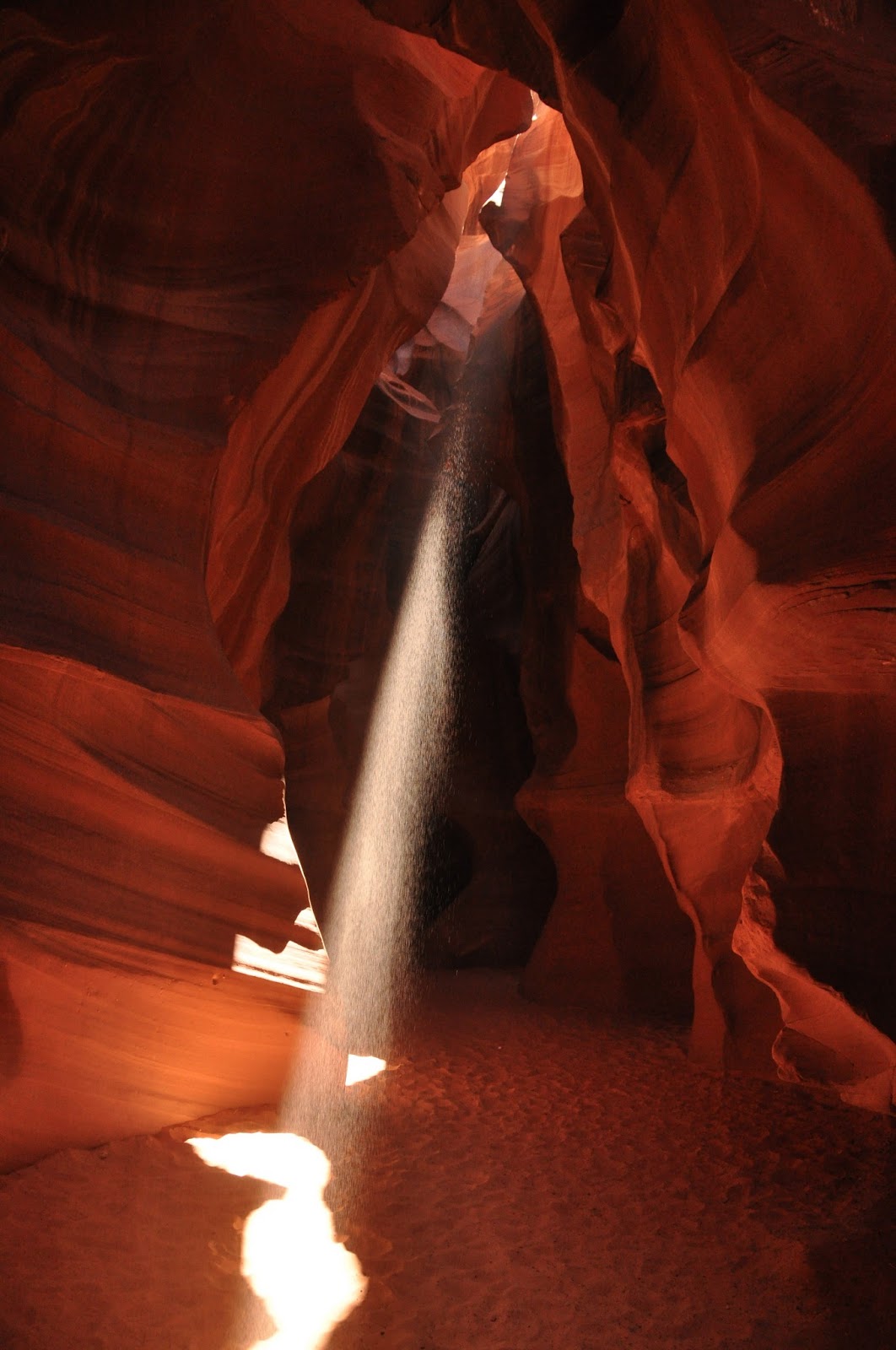
Upper Antelope is the star and the most well-known of the Arizona slot canyons. It is also the most visited. Tours are strictly controlled and timed. Tour guides worked with each other to coordinate where each group stop and for how long. They staged "shows" inside the canyon - threw dust into the shafts of light that came through the canyon near midday for the photographers, all geared up with their tripods. It's theatrical. In a way, the crowds and the theatre detracts from the experience although the "shafts of light" are legendary and are what drew the crowds. In fact, midday tours are more expensive than other times because of the light show.
The canyon without the theatre is still very beautiful. It is the tallest of the slot canyons in the area and I could imagine it without the crowds. If you're visiting, do your utmost to avoid the high season - I can see it would be difficult to enjoy it when you're rushed through and have to jostle for space.


Reminds me of a Lawren Harris painting


This is called "Sunset at Monument Valley"

Shafts of light in different parts of the canyon - photographers are lined up three rows deep to catch this display - some kneeling in the front row, some standing in the middle and the ones without tripods leaning against the wall!


This is "the heart" of the canyon

Another staged effect - sand fall


All you need is an ancient city on the other side to think that you were in Petra...
What you see instead are the open air jeeps the tour companies use to transport people to the canyon. We were on a full day tour so was driven in an SUV.
Slot Canyon #3 Upper Antelope Canyon
Upper Antelope is the star and the most well-known of the Arizona slot canyons. It is also the most visited. Tours are strictly controlled and timed. Tour guides worked with each other to coordinate where each group stop and for how long. They staged "shows" inside the canyon - threw dust into the shafts of light that came through the canyon near midday for the photographers, all geared up with their tripods. It's theatrical. In a way, the crowds and the theatre detracts from the experience although the "shafts of light" are legendary and are what drew the crowds. In fact, midday tours are more expensive than other times because of the light show.
The canyon without the theatre is still very beautiful. It is the tallest of the slot canyons in the area and I could imagine it without the crowds. If you're visiting, do your utmost to avoid the high season - I can see it would be difficult to enjoy it when you're rushed through and have to jostle for space.
The canyon without the theatre is still very beautiful. It is the tallest of the slot canyons in the area and I could imagine it without the crowds. If you're visiting, do your utmost to avoid the high season - I can see it would be difficult to enjoy it when you're rushed through and have to jostle for space.


 |
| Reminds me of a Lawren Harris painting |

 |
| This is called "Sunset at Monument Valley" |
 |
Shafts of light in different parts of the canyon - photographers are lined up three rows deep to catch this display - some kneeling in the front row, some standing in the middle and the ones without tripods leaning against the wall! |


 |
| This is "the heart" of the canyon |
|
| Another staged effect - sand fall |

 |
| All you need is an ancient city on the other side to think that you were in Petra... What you see instead are the open air jeeps the tour companies use to transport people to the canyon. We were on a full day tour so was driven in an SUV. |
Monday, 29 April 2013
Arizona slot canyons #2 Rattlesnake Canyon
Antelope Canyon is what everyone has heard of, but Rattlesnake Canyon is actually more gorgeous - it's an artist's dream. But it is not as accessible - it is on multi-levels, visitors have to climb up and down ladders, which is why the Navajos didn't promote it except for small parties.
You can judge for yourself based on the photos below.

I'm at a loss for words to describe these...


You can judge for yourself based on the photos below.
 |
| Entrance to Rattlesnake canyon |
 |
| The first of many sand "sculptures" |
 |
| You have to go under this arch |
 |
| Squeeze through this narrow opening - like a rattlesnake |
 |
| And it gets tighter... |
 |
| and tighter... |
 |
But then look up and gawk - at the sculptures and paintings on the walls |

I'm at a loss for words to describe these...


 |
Picture yourself a snake wiggling through this |
 |
| Towards the light |
 |
| Climbing down is harder than climbing up - unless you're a snake, of course |
 |
| And you're back into the world, sort of - it's still very remote. You pinch yourself to see if you were dreaming... |
Sunday, 28 April 2013
Arizona Slot Canyons - #1 Owl Canyon
The red sandstone slot canyons near Page, Arizona, are some of the most photogenic in the world. We visited five of them in one day with a Navajo guide - the only way to visit, as all five canyons are on Navajo land. We started at 9 am and finished very close to 5 - a long day, but exciting as all five canyons are different and beautiful in their own way.
The first canyon we visited was Owl Canyon - the widest, the most open and easiest to access. We were the only ones there that morning, so we took our time warming up our cameras, picking up the particular technique needed to photograph these red sandstone canyons. Our guide, a photographer himself, taught us the best way to bring out the red sandstone is to make sure we cut out the sky from our photos. True enough, the moment we included a patch of sky, the sandstone would look washed out. You won't see much sky in the pictures below except for the entrance shot.


The first canyon we visited was Owl Canyon - the widest, the most open and easiest to access. We were the only ones there that morning, so we took our time warming up our cameras, picking up the particular technique needed to photograph these red sandstone canyons. Our guide, a photographer himself, taught us the best way to bring out the red sandstone is to make sure we cut out the sky from our photos. True enough, the moment we included a patch of sky, the sandstone would look washed out. You won't see much sky in the pictures below except for the entrance shot.
 |
| Entrance to Owl Canyon |
 |
You can see the difference in colours here when the sky was included and when it wasn't. |

 |
| I wouldn't be able to capture this shot of the canyon's namesake if I didn't have my 18 - 200mm zoom (it's maxed out at 200mm). It was high above us near the top of the canyon. Our Navajo friend didn't want to look at it even though he pointed it out to us. It was supposed to be bad luck if the owl's evil eyes caught you in its gaze. As you can see here, its eyes were closed, so we were quite safe... |
 |
| The contrasting shades were just sunlight playing tricks |
 |
| There were still some tight spots even though this is the widest canyon |

 |
A closeup of some of the sandstone - some were pock-marked but some were smooth |
 |
| An overhang was used to block out the sun to produce the right light for the camera |
 |
| Plenty of these swirls everywhere - imagine the water whirling through |

 |
| Yes, incredible! These smokestacks greeted us at the exit of the canyon. They are from the power generation station - a coal plant, believe it or not, right beside the hydro plant near the Lake Powell dam. |