Tuesday, 13 December 2022

Southwest Road trip - Antelope Canyons

If you haven't already visited the slot canyons, you have probably seen iconic images of the Antelope Canyons in Page, Arizona.  There are two of them, Upper Antelope and Lower Antelope, tourist meccas with visitors from all over the world. I was last in Page to see these slot canyons in April, 2013 - it was busy but not as crowded as things have since become. I was also able to sign up at the time for a private tour of five slot canyons in the area.  For my post on these canyons, please click on Arizona in the header of this blog.  This time we were visiting in what is supposed to be "low" season yet I still had the feeling of being rushed through a crowded tourist area with the next group hot on our heels.  This may be particularly obvious because I was always the last one in our group to leave a spot! 

But the slot canyons are as spectacular as ever.  I was able to stand back and enjoy the beautiful swirls and lines in the rock face already knowing what to expect, also having already heard the tour guide's script before I didn't need to stand around to listen any more.  

On my first visit, I had found the Lower Antelope Canyon very peaceful, stunning in its beauty - almost conducive to poetry.  But this time around it was a completely different experience - the over-enthusiastic guide created an almost marketplace atmosphere, although his enthusiasm should probably be applauded.  

The Upper is narrower on top but wider at the bottom.  The Lower is the other way round, narrower at the bottom which makes it sometimes hard to walk through.  You can see in the some of the photos below that it can be a tight squeeze at times.  

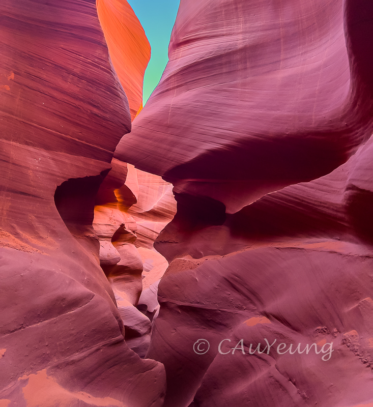
Upper Antelope is above ground while the Lower Antelope Canyon is below ground which made a difference in the lighting.  You will notice in the images below that the rocks can come out in different colours - that is because of the very dim light in the canyons which doesn't always allow the natural sandstone colour to come through and also made the rocks seem surreal at times - all the more beautiful in many ways.

The first nine images are from the Upper Canyon, the rest from the Lower.


Upper Antelope walls - looking up

This provides a perspective of the inside of Upper Antelope - you are walking between canyon walls but still relatively wide compared to Lower Antelope.


You can almost see the water gushing and turning through in these swirls


The layers of rocky swirls make for nice abstracts


This is the exit/entrance to the Upper Antelope Canyon

Entrance to the Lower Antelope.  In my first visit, this was the exit.  They have reversed the direction of the tour.

Lower Antelope - swirls are a little different


The guide referred to this as the Johnny Depp profile (as in Pirates of the Caribbean)...


Love this perspective looking up - reminded me of sunset in the canyons

This is a perspective on the height of the canyon


It's a tight squeeze!


Looking down 
Using your imagination you can probably see all kinds of animals carved on the walls, like this one.


Or make up your own abstracts


Another sunset landscape


Reminded me of candy making


This is where we exited - used to be the entrance.  It makes sense for them to reverse the direction as the descent was quite scary not knowing where you're "falling" into when you first enter.


The slot canyons are the sort of landscape you could visit ten times and still capture different perspectives of it - if only it weren't so crowded... 

Thursday, 8 December 2022

Southwest Road trip - Sedona to Page

The next stop on our trip is Page and the road between Sedona and Page is very scenic.  The section of Highway 89A between Sedona and Flagstaff cuts through red rocks in the southern part but as the road climbed, it changed over to forested canyons - all this within the mere 30 miles between the two cities.  There was one scenic stop that looked out onto the deep  canyons, a change in scenery from the red rock desert of Sedona although you can still see the red rocks under the trees.


We stopped at the Cameron Trading Post for lunch, trying their delicious specialty Navajo fried breads.  


The spectacle along the highway continues as we approach Page.  Thanks to my friend and driving partner LW for these two photos.


It is a mere 158 miles between Sedona and Page - what should be a less than 3 hour drive turned into a good part of the day.  We had to cut the stop at Marble Canyon on the way because we had to make it to Horseshoe Canyon for the golden hour, which is very early these days because sunset was around 4:30-5.  That is one of the cons of travelling at this time of year - very short days - but the advantage is smaller crowds.


Stunning rocks surround the Horseshoe Bend


The Horseshoe Bend is basically an "incised meander" of the Colorado River.  It's my second visit - thankful that this time I made it for the golden hour and the boat cooperated with a cruise around the bend.  See how the colour changes as the sun goes down.


Moonrise brought on the magic...


and the goblins...


Tuesday, 6 December 2022

Southwest Road trip - Sedona


This is at least my fifth road trip in the American Southwest (I've lost count!) but it almost felt like it is my first visit!  This time we covered Prescott, Sedona, Page, the Grand Canyon (last minute itinerary change due to weather) and the Death Valley. The scenery is as awesome as ever.  It is, however, my first visit to Sedona - don't know how I could have bypassed it all these years!  Prescott is an hour and half west of Sedona and we started our road trip there.  

There are some neat rock formations in Prescott, particularly near the Watson Lake area in what is called Granite Dells.  Developers have also taken advantage of this natural environment to build unique communities around these rock formations.  


Granite Dells at Watson Lake - as usual we barely missed the golden hour (because we didn't look too carefully at the carefully researched directions), otherwise the rest of the rocks should have that golden glow you see at the top!  We had to use our imagination - it was also a blustery cold day!


Down at the launching area on the lake, it's a totally different perspective


These are rock formations in people's front yards and backyards! 


The Red Rock Scenic Byway starts at I-17 and ends in Sedona, going through Oak Creek Village, where we stayed.  This is the most scenic part of the route and I wish I had not been driving and able to take some photos of the drive itself - a spectacular curve of a road with red rocks lined up on either side coming at you as you drove through.  There will have to be another visit...

We spent two days in Sedona, taking in the key sights, Bell Rock, Castle Rock, Cathedral Rock, among others which you can see below.  We did short hikes on level ground, no daring escapades to see spectacles like the Devil's Bridge, that may have to wait for another life. 

Bell Rock

Castle Butte


Close up of the rock face of Castle Butte - this reminded me of the carvings on the stone walls of Angkor Wat in Cambodia


The backdrop for the Chapel of the Holy Cross


The Chapel was built into the rock face - an architectural marvel. 
Below is the inside of the Chapel.


The town of Sedona took full advantage of the red rocks and incorporated them into the architecture. It was a pleasure strolling through it and noticing these little touches.
 
 
This portal for the Pioneer Pathway nicely framed the red rocks in the background

The tiled roof of this hotel echoed the colour of the rocks in its "backyard"

The beautiful landscape can be seen from many outdoor venues.  Here the red rocks are nicely framed (see the closeup below, Snoopy Rock is on the right, Camel Rock on the left)


Love the colourful cacti - never seen a purple one before


Cypress Trees look so unique amidst the red rocks


We made a point of catching the golden hour and sunset on the red rocks - the first afternoon from the Airport Mesa after a short hike on the Airport Overlook trail.  The three images below would give you an idea of how the red rocks looked as the light changed.  It was worth standing out there in the cold.

Golden hour at Capital Butte and Coffee Pot Rock from the Airport Mesa


Panorama at sunset
 
Just after sunset as the lights began to come on


The second afternoon we ventured out to look for the elusive Red Rock Crossing.  All the directions we got online were not very specific. It took some detective work and several U-turns to find it - a surprise given that it seems to be an iconic spot for sunset chasers.  The gatekeeper at the entrance to the Red Rock State Park actually had a printed slip of paper giving directions to drivers asking about the location.

Cathedral Rock in the golden hour

Cathedral Rock at sunset and moon rise


Looking in the direction of the sunset just after the sun set