Showing posts with label waterfall. Show all posts

Wednesday, 15 April 2026

Chile/Argentina - Cajon de Maipo

 We did a day trip to El Yeso a turquoise lake (actually a reservoir) in the much touted Cajon de Maipo area.  I expect it would be much more spectacular in the spring when there is still snow on the mountains.  But in the height of summer, it is very brown.  We did a short hike along the lake before having a late lunch in the area, heading back to Santiago before the rush hour.  A leisurely day with the mountains. 

We had time to visit Sky Costanera located at the top of the Costanera Tower to do some night shots of the city.  The facility is on two levels and provided a panoramic 360 degree view of Santiago.   There was a live band providing entertainment and a festive atmosphere with people dancing as the sun set.

View of the Andes from the valley


The reservoir at El Yeso


Beautiful sweeping lines of the mountain side


Hierba Blanca (according to Google)


Waterfalls in El Yeso


Looking out from Sky Costanera in the golden hour


Night views from the observation deck


Friday, 8 November 2024

Nfld & Labrador - Eclipse, Martin's Bay and Killiniq

 We had our first polar bear sighting the day we were at Nachvach Fjord.  I forgot to post the photos in the last post so here they are - two bears in one day on top of seeing the Nachvach.  It was an overwhelming experience.  The bears were quite far away and it took a lot of pointing and describing for my lens to find it.  The first sighting was on a black rocky shore.  The second bear looked a little mangy and it decided to go to sleep after it got tired of staring at us.


Our next stop is Eclipse Sound - a rugged, rocky canyon with a stepped waterfall at the end.  We hiked on the rocky top of the canyon to see the beautiful waterfall at the end.  When we returned from the hike, the zodiacs took us right into the canyon  to get a closer view of the lower falls.  Some of the hollow caverns along the side of the canyon made for excellent acoustics and the ship musicians gave us another concert in nature's theatre.  

View of Eclipse Canyon from the top


and from below


The lower falls


The upper falls with its beautiful S curve


Purple mountain heather

Velvet bells


The rocky top


Looking seaward from the canyon
Amazing rock formation on the canyon walls


Natural caves on the canyon walls make for great acoustics


Concert by the canyon caves


The following day was the first time we were unable to do anything because of weather, in this case, fog.  We could not land at Martin's Bay and so some brave souls on board did their polar dip.  Quite a spectacle for the audience but it was cold and windy - it was tough even watching, never mind dipping.  


We did ended up going out on a zodiac cruise after dinner to get a taste of the mist and get some misty shots.  We were once again treated to another concert by Adam Ruzzo whose nice tenor voice warmed us in the cold night.  The expedition team tried so hard to make it up, that in itself is heartwarming.


We were lucky the fog only lasted one day and we were able to land on Killiniq, the second last stop on our cruise.  Killiniq island, at the northernmost tip of Labrador at the entrance of the Hudson Strait, has the unique status of being the only land border between Nunavut and Newfoundland and Labrador.  The provincial boundary crosses the island, with the eastern section in Newfoundland and Labrador and the western section part of Nunavut.  

While we were on a cruise around the island before the hike, I saw what looked like a hawk with a prey in its claws.  As usual I don't have the right lens with me and so the photo was not too sharp.  The island itself is not particularly spectacular but makes for a good hike among the rocks.  There were a lot of debris from the community that was there before evacuation by the government of the Northwest Territories.  The only thing left there was an automated remote radio transmitter for the Iqaluit coast guard.  

Hawk with what looked like a vole


Looking down at the bay from the top


Looking up from the landing


Next post:  our last stop on the cruise before disembarkation


Friday, 1 November 2024

Nfld & Labrador - Torngat Mountains National Park

We finally arrived at the Torngat mountains and they were as stunning as we expected.  Weather was a bit drizzly but the clouds added to the drama.  After sailing into the Saglek Fjord, we were taken further in on zodiacs to get a close up look.  It was the highlight of the trip as the Torngat Mountains was the reason why we went on this cruise. The mountains rose straight from the sea on both sides of the fjord.  There were no trees to break the lines of the mountains as we are now above the tree line and so it was one mountain after another going into the fjord in layers.  Together with the mist, the scenery almost begs to be painted.  

Saglek Fjord at the southern end of Torngat Mountains National Park


Mist descended and the drizzle turned into rain as we went back on board


After the exhilarating ride into the fjord on the zodiac, we moved on to the Torngat Mountains National Park Basecamp, where we went on a guided hike with our resident geologist and chaperoned by a bear guard, as we are now officially in polar bear country.  The hike took us to several waterfalls and the many colourful rocks that filled the landscape.  The landscape was nothing like what we saw in the fjord - the hills were rounded, probably from glaciation.  The camp itself consists of a cluster of space age like globular tents which  provide accommodation for the few visitors here, whether for research or for adventure.

Torngat Mountains National Park is part of the land governed by the Inuit people and the park is co-run by the Canadian government and the Nunatsiavut government.  The mountains are a spiritual place for the Inuit and the name Torngat came from the Inuktitut word Tongait meaning "Place of spirits".


The hike took us up this incline to the foot of the hill.  The advanced hikers actually went to the top of the hill.


Rocks with beautiful patterns on the way up, including this with a sign beside it that claimed it to be "the oldest rock in Labrador"!


Three waterfalls on the hike


Bog labrador tea


Labrador Indiant paintbrush (not verified)


View of the bay and the Base Camp from the top


A surprise caribou on the way down


Rocks and more rocks...


View of the bay


The space-age looking tents for visitors at the base camp.  Thanks to my fellow traveller Jean, who had a personal tour of the base camp and provided more details.  She was able to take some photos of the inside of the tents shown below.  The white and red colour domes are for research scientists while the green domes are for guests.  Each tent has its own heater.


Inside the tents - Photo credit: Jean Liao

Photo credit:  Jean Liao


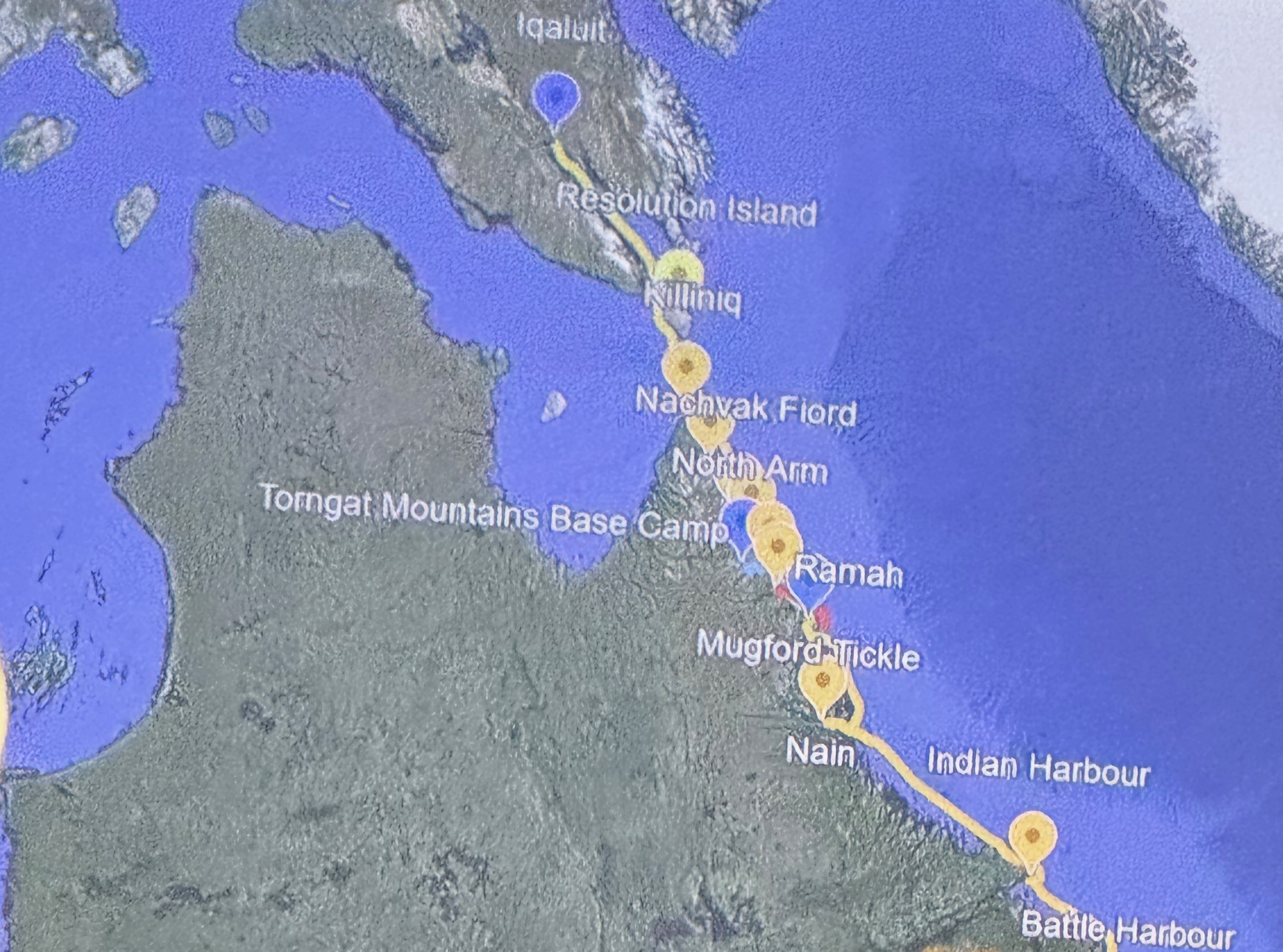
Map of our itinerary in Labrador