Saturday, 14 October 2023

Canadian Arctic - Coningham Bay to Prince Leopold Island

Continuing our journey north from Gjoa Haven, we travelled through the Franklin Strait to Coningham Bay, on the southeast coast of Prince of Wales Island.  The bay is very shallow and there is a large sandbar across its entrance that nearly encloses it at low tide. The richness of the waters here made it an ideal feeding ground for beluga whales but at the same time made them prime targets for polar bears when they are trapped by low tide.  It was therefore no surprise that when we arrived in the bay, we saw a polar bear family feasting on the carcass of a beached beluga.  I was surprised though that the bear cubs were also feeding on the carcass, at least there was blood on their faces.


Polar bear family at beluga whale carcass


The expedition team reported a total of 12 bears that morning plus one dead one.  Except for the ones near the shore, the others were quite far away and difficult to photograph.  


The one dead bear was very unusual, according to the Inuit couple on board, they have never seen one all these years.


Great care was taken to protect us from polar bears.  Whenever we go on shore, scouts were sent ahead to make sure there are no bears around and bear guards establish a perimeter within which we are safe.  We are not allowed to wander beyond that perimeter.  As we were going into the bay, each zodiac has a rifle just in case, afterall we did see a bear go into the water.  

Sunset as we sailed through the Bellot Strait

From Coningham Bay we sailed through the Bellot Strait which separates Somerset Island from the Boothia Peninsula, which is the northernmost point on the mainland of North America.  The strait also marks the first meeting of the Atlantic and Pacific tides north of Magellan Strait.


Zenith Point, at the tip of the Boothia Peninsual, marks the northermost tip of the North American mainland.  We celebrated on deck with champagne as we passed.  It is a significant point in the Northwest Passage.   We also saw Franklin's cairn as we passed along the strait.

Cairn on south shore


After Coningham Bay (5) and the Bellot Strait, we travelled north along Prince Regent Inlet
 to Port Leopold.  Port Leopold is an abandoned trading post and is the site of the first winter camp for the first major Royal Navy search for Sir John Franklin's missing expedition.  We were originally going to have hikes at Port Leopold, but the scout sighting of polar bears meant we had to cancel most of the hikes, including the hike to the Hudson Bay Trading Post.  It's a good thing we were able to see it from the ship (with a long lens!).  We did see the remains of a Thule settlement, with remains of whale bones which were used in their construction.   The Thule culture were the ancient predecessors of the Inuits.

Ruins of Thule house


Whale bones at the Thule sites.  Whale bones are used in the construction of Thule houses and their placement had a certain symbolism within the culture.  


Hudson Bay Trading Post


From Port Leopold the ship cruised to Prince Leopold island just a short distance away.  The island, with its steep cliffs rise about 750 feet and is noted for its nesting birds, including fulmars, murres, common eider and kittiwakes, among others.   Unfortunately when we arrived, it was too dark to see the birds, if there were any left.  Many may have gone south already.


Prince Leopold island itself is an impressive site - shaped like a crown almost, as befits its name!


Tuesday, 10 October 2023

Canadian Arctic - Gjoa Haven

One of the highlights of this trip was an opportunity to visit northern communities to get a glimpse of their way of life.  The third day into the trip, we visited Gjoa Haven - population 1349 living in 339 private dwellings (2021 census).  Gjoa Haven, a hamlet on Prince William Island, was named by Norwegian explorer Roald Amundsen after his ship Gjoa.  Amundsen and his men arrived here in 1903 while exploring the Northwest Passage and spent two years here learning arctic survival skills.  The Hudson Bay Company opened a trading post here in 1927 marking the beginning of permanent European style settlement. (Wikipaedia)

Gjoa Haven means "lots of fat' pointing to the abundance of sea mammals in the area.  It is noted for being the closest settlement to the wrecks of the HMS Erebus and HMS Terror from the lost Franklin expedition. This is expected to lead to increased tourism.

The average high in winter is -30C to give you an idea of arctic temperatures.  It was above 0C the day we landed but there was a wind chill and it felt colder walking around town as there was little shelter, as you can see from the photos below.  The settlement was very sandy as a result of glacial action.  

We landed on the beach and was welcomed by a group of local guides.  You can see from the photos that this is no ordinary "cruiseport" visit nor is this your average cruise for that matter.  Writing this as I sit at home back in the midst of a bustling metropolis, I realized what a culture shock it had been for us to clamber up from the beach and walk through town, to see first hand how different life is in these northern communities.  

The beach where our zodiacs landed


One of our guides
Director John Houston who was on board with us took us to the local inn where there was an exhibit of soap stone carvings.


Health & Social Services


The local high school


Random houses


Nattilik Heritage Centre is the Museum.  There are some interesting pieces there.


Musk ox horn soup ladle


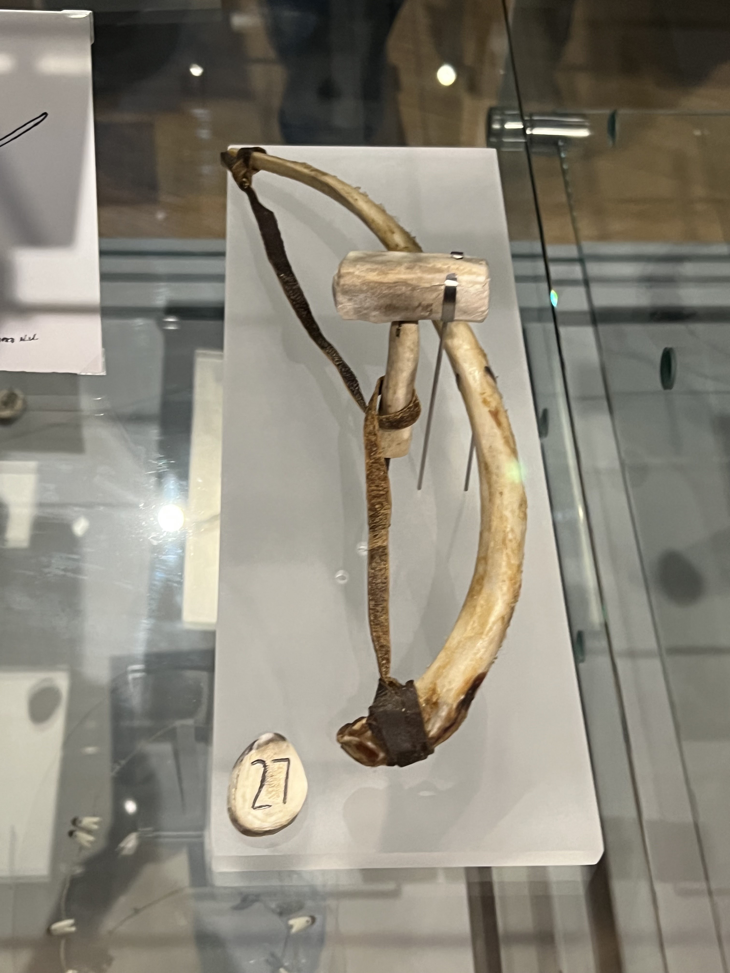
“Cordless drill” caribou antler, steel, seal hide, rib bone


Tool bag made with fish skin


Community Centre

We were entertained by the local community at the Community Centre.  Three drum dancers performed and visitors were invited to try their hand.  Inuit drum dancing is often accompanied by song, touching on experiences of daily life, including love, hunting, etc.  There is a short video recording of the drum dance here.


The chorus accompaniment


School children performed a square dance - very popular here, with its roots in the round dances from Great Britain left behind by the whalers who were active here earlier.  Here is a short video of the performance.


It was heartwarming to see the light in the children's eyes and their beaming faces when they saw the gifts that were donated on our behalf - 50 sets of hockey equipment plus several hundred hockey sticks.


As I walked backed to the ship, I saw this house with an outbuilding labelled "Heartbreak Hotel"...  Not to overinterpret the meaning, but this must be quite a desolate place in the winter, smiling faces regardless.


Sunday, 8 October 2023

Canada's Arctic & Greenland - Port Epworth

I am sharing with you here a memorable journey to the Canadian Arctic via the Northwest Passage, a historical sea lane through the Canadian Arctic archipelago.  We travelled with Adventure Canada and boarded the Ocean Endeavour in Kuqulutuk, Nunuaut, travelling eastward along the passage then north to the high Arctic, crossing the Baffin Sea to Qanak before going down the Greenland coast to our final destination, Kangerlussuaq.  Almost all the boardings and landings (usually wet) were via zodiac so I was glad I have had a similar experience visiting Svalbard which helped. Zodiac cruising could be unpredictable, what started out as a calm ride could end up being so stormy on the return trip that even docking alongside the ship could be hazardous.  

It was for me a trip of a life time, at times physically strenuous and challenging for both the senses and the intellect in the sense that I was bombarded with new experiences and information, sometimes outside my comfort zone yet at the same time exposing me to exciting new environments and contexts that I have never experienced before.  This is not to mention the amazing vistas of the tundra and the Arctic ocean, the Greenland fjords and monstrous icebergs.  Breathtaking and mind boggling - but that's what an adventure is all about!

It took me a while to digest all this after the 17 day long trip and the upcoming blog posts will be my attempt to make sense of what I have seen and heard on the journey.  

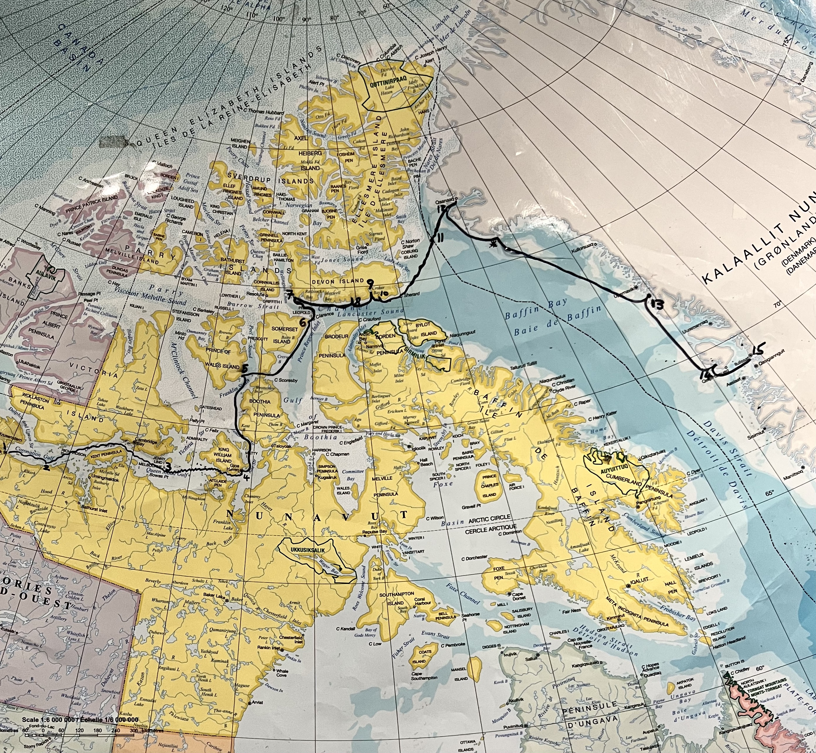
Our route on a polar map


This is the original route but we were unable to get to Grise Fjord on Ellesmere Island because of packed ice. 

The top deck of the Ocean Endeavour, where we spent a lot of time with our cameras


As we travelled east, our first stop was Port Epworth or Kuluktuluq, which means Tree River.  (You will notice that most places in Nunavut have two names, the English name which is often named after some important person in England but doesn't tell you anything about the place, and the Inuit name, which usually tells you something about the place.)


Port Epworth from the ship


Close-up of the sedimentary rock formation at Port Epworth.  

Geology was the main reason we stopped here.  This is where we would see stramatolites, layered sedimentary formations created by microorganisms 1.9 billion years ago, the first preserved form of life on this planet.  These microorganisms produced adhesive compounds that cement sand and rocky materials together, forming bacterial mats one on top of the other.  I

t was a 3.5 km return hike over boggy tundra to get to the viewpoint where there was a platform of stramatolites. Because the hike involved some clambering over rocks without a trail and there was a height gain equiavlent to 14 floors, the operation was declared an advanced hike. No surprise then that everyone suddenly became an "advanced hiker" because they all wanted to see the view of the stromatolites up on the platform!

Boggy terrain - it is best to walk in wet boots over this kind of wet bog, but if you also have to climb up the hillside, the boots didn't have as good a grip as your hikers.  But walking in your hikers meant wet feet even if they are waterproof as you could sink right into the bog and the water come over the top!


Brilliant fall colours on the Arctic tundra - what a treat!


Lichens abound on the rocks


Stromatolites


This was the view we all came for!  The expanse of the stromatolites in front of us on the plateau, the bear guard in orange for perspective, the Tree River in the distance.   Geologist Dr. Marc St. Onge was there to explain the history of the stromatolites.  The stromatolites were some of the earliest traces of life - organisms that generated the oxygen we have today.  The place we were standing on used to be the bottom of the sea.


Table of daily finds kept on board


Stromatolites come in all sizes and this one gives you a relative size of the ones we were standing on.  You can also see some in cross-section on the hillside.  The humans are there to provide perspective.


Tbe Arctic Willow, much smaller than its relative in temperate zones because of temperature and precipitation factors.

After the climb up to the stromatolites platform, we took our time going back to the ship, enjoying the many Arctic plants on the tundra.  The afternoons on board were filled with lectures - on that particular day it was one on the fascinating Geological History of Arctic Canada and Greenland by Dr. Marc St. Onge.  This was followed by another interesting lecture on "How do Arctic Animals Survive".

Postscript: Margaret Atwood was inspired by her trip to Port Epworth with Adventure Canada to write a short story Stone Mattress in her collection "Nine Wicked Tales".  It's a murder story but it also gives you a sense of shipboard life!

Next stop:  Gjoa Haven