Canyonlands National Park is only half an hour from Arches, but it offers a totally different kind of landscape. While Arches is raised high up, Canyonlands is, as its name suggests, mostly canyons cutting deep into the Colorado Plateau. What I find most striking is how it showed us the many layers and levels of the land that has lifted (or sank), exposing ancient sediments through erosion by the Colorado River and its tributary the Green River. It would have been wonderful if we had a geologist come along to explain all this to us. As it is, we're just there for the views with the odd sign explaining what was in front of us.
Two striking buttes near the turnoff into Canyonlands - Monitor and Merrimac. These two are at eye level while many of the buttes in the park are in the canyons. There is a simple diagram on a signboard showing their geologic profile.
 |
| Monitor and Merrimac |
 |
| This huge rock formation near Monitor and Merrimac reminded me of a turtle |
From the Visitor Centre, where I saw a stunning photo of the Shafer Trail Viewpoint, we made our way down the road in search of that amazing viewpoint but likely went down the wrong path and ended up with some view but not quite the one I saw at the Visitor Centre. We were not going to see the actual Shafer Trail Viewpoint until later in the day.
 |
Not quite Shafer Trail Viewpoint but is reminiscent of the Grand Canyon landscapes |
The Mesa Arch was top of our list as it is supposed to still have the red glow on the underside from dawn till mid-morning. While the trail was not hard to do, there is one spot where it is a little steep and the rocks rather slippery which served as a deterrence for some of us. I did manage to get down to see the arch close up and even better, see the canyons beyond the arch.  |
| This is the descent to the arch - mix of rocks and sand, slippery in places but mostly okay |
 |
| Mesa Arch with the afterglow still visible on the underside |
 |
| The expansive view beyond the Arch |
 |
| This looks like a potential arch |
Our next stop is the Grand View Point Overlook at the tip of the Island in the Sky scenic drive. From this overlook, we were feted with a panorama across miles of corruagated canyons, ones that appear to be folded and rippled due to erosion. It is mesmerizing to get this bird's eye view of the canyons.
 |
| Love these Utah junipers! |
 |
| Layers upon layers of canyons as far as the eyes can seen stretching all the way to the La Sal mountains |
 |
| Closeup of what's in the canyons |
 |
| These are rock formations above the canyons |
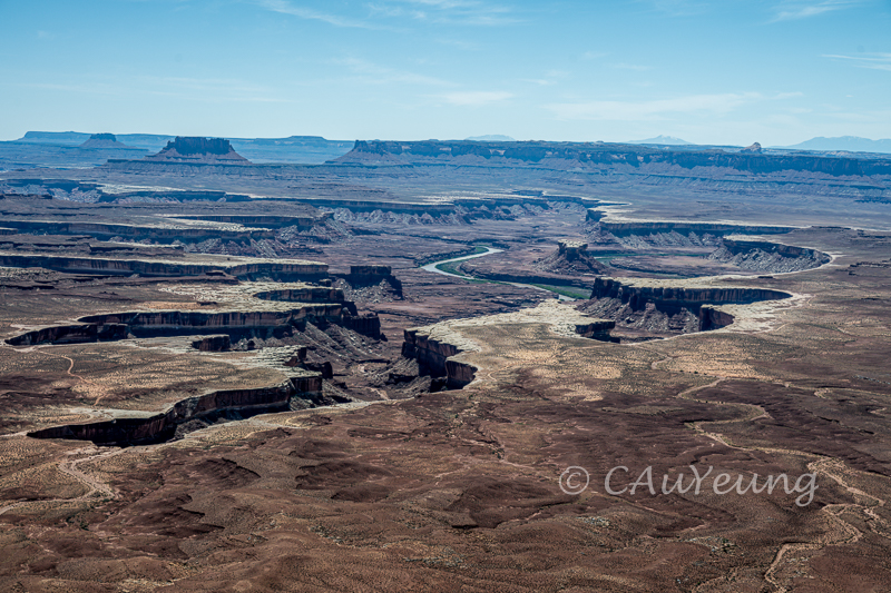
The Colorado River and its tributary the Green River meandering through and continuing to cut into these canyons.
 |
I have learned that if you can see the La Sal Mountains, it is the Colorado River in front of you; if you can't see the La Sal, it is the Green River. This view is from the Grand View Point Overlook. |
 |
| Tumbleweed |
 |
| This reminded me of a fancy mansion with rooftop garden and a garden in front at several levels. |
 |
| Green River cutting through |
 |
This one looks like a bonsai
|
 |
Shafer Trail Viewpoint - finally found it before we left the park! What a view!
Our last stop was at Dead Horse Point State Park. We had debated whether we should stop there on the way out of Canyonlands and we were sure glad we did. It offered more spectacular views of the Colorado River and the canyons.
Panorama from the Dead Horse Point State Park Overlook |
 |
| The side wall of the canyon overlook we were standing on hit by golden hour glow - it's time to go... |


Catherine, a person could spend a lifetime in that fantastic area and not repeat images exactly. I have been in some of that area, and never tire of seeing someone else's photos. You were lucky with some of that whimsical cloud cover. You also have the energy to cover so much territory, good for you. Bye, Andy.
ReplyDeleteThanks, Andy. Glad you enjoy this.
DeleteStunning photos! Peggy
ReplyDeleteThanks, Peggy!
DeleteStunning panoramic shots!
ReplyDeleteThanks, Frances.
Delete